St Leonards was started in early 1826 on land owned by the Eversfields(an old
local ironmaster family) originally used for farming. The land was bought by a London
architect James Burton to build his idea of the ultimate up-market resort. He died in
1837 and his son Decimus continued to build St Leonards to the west towards Bulverhythe .
The first railway to the area arrived in 1846 and was built from Lewes to St Leonards.
A second line opened in 1851 from Ashford via Rye to Hastings across the Romney Marshes .
Finally in 1852 the London to Hastings line via Battle was opened, this line together
with a tunnel to St Leonards Warrior Square and then Hastings provided the current
railway infrastructure.
Once the railway was in place and the tourists started flocking in, then the land between
Hastings and St Leonards(all owned by the Eversfields) was sold to provide more properties.
On the sea front is the art-deco building known as Marine Court which was finished in 1937
resembling an ocean liner. At its time of construction it was the tallest block of
flats in the United Kingdom, comprising of 153 flats and 3 restaurants.
Views
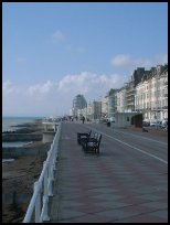
St Leonards is well renown for its promenade which provides views to Hastings East Cliff
and the South Downs at Eastbourne.
St Leonards as a high quality resort is blessed with a number of open gardens.
Warrior Square Gardens - Opened in 1852 in which a statue of Queen Victoria was installed in 1902.
St Leonards Gardens - Originally the Burton family garden it was bought by St Leonards
in 1879, and gave rise to the name Maze Hill as it contained a maze.
Gensing Gardens - Bought by the Council in 1872 the name comes from the original farm.
Markwick Gardens - Created in the 1860s primarily for the use of residents
of Markwick Terrace.
Services
St Leonards has a reasonable range of local services, with buses and trains providing
good transport links.
The main shopping areas are at nearby Hastings , or further along the coast at Glyne Gap
originally a smugglers haven , but now a retail park.
Map
St Leonards On Sea is shown as the red symbol on the map.
Nearby Villages (click on symbol to see the village page)


 St Leonards was started in early 1826 on land owned by the Eversfields(an old
local ironmaster family) originally used for farming. The land was bought by a London
architect James Burton to build his idea of the ultimate up-market resort. He died in
1837 and his son Decimus continued to build St Leonards to the west towards Bulverhythe .
St Leonards was started in early 1826 on land owned by the Eversfields(an old
local ironmaster family) originally used for farming. The land was bought by a London
architect James Burton to build his idea of the ultimate up-market resort. He died in
1837 and his son Decimus continued to build St Leonards to the west towards Bulverhythe .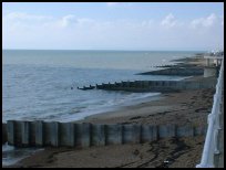 St Leonards is well renown for its promenade which provides views to Hastings East Cliff
and the South Downs at Eastbourne.
St Leonards is well renown for its promenade which provides views to Hastings East Cliff
and the South Downs at Eastbourne.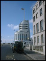 St Leonards has a reasonable range of local services, with buses and trains providing
good transport links.
St Leonards has a reasonable range of local services, with buses and trains providing
good transport links.


